

Last month, while you were checking your phone or queuing for coffee, Kuala Lumpur’s drainage systems quietly moved billions of litres of water through the city. You didn’t notice, and that is exactly the point. When urban flood infrastructure works, it stays invisible.
Ask most residents whether KL can handle heavy rain and you will likely get a weary look, followed by stories about that underpass, that junction, or that afternoon when traffic stood still for hours. Failures are memorable. Successes fade into the background of daily life, unnoticed and uncounted.
What many people don’t realise is this: during most weeks of the monsoon season, Kuala Lumpur already handles rainfall volumes that would overwhelm many other cities. The floods that make headlines are not the norm; they are edge cases, moments when several stress factors align and push the system beyond its limits. The rest of the time, vast amounts of water are captured, delayed, diverted, and released in a carefully coordinated process that happens entirely out of sight.
When Rain Becomes a Problem
A flash flood occurs when rain falls faster than the ground can absorb it or the drainage system can carry it away. In dense cities like Kuala Lumpur, where concrete and asphalt have replaced natural soil, nearly every raindrop becomes surface runoff.
KL’s geography makes this even more challenging. The city sits in a valley surrounded by higher terrain, so water naturally converges toward the urban core. Add intense tropical downpours, storms capable of delivering a month’s worth of rain in a single afternoon, and the ingredients for urban flooding are firmly in place.
What stands between heavy rain and urban chaos is infrastructure: drains, tunnels, pumps, dams, and retention basins working together to keep water from becoming either an inconvenience or a catastrophe.
The Water You Don’t See
Consider a typical heavy rain event in central Kuala Lumpur. Within the first 30 minutes, street-level drains collect runoff from roads and buildings, channelling it into underground networks. At the same time, retention ponds across the city, some disguised as parks, others hidden behind offices, begin filling, temporarily holding millions of litres of water that would otherwise rush toward the Klang River and its tributaries.
Upstream, river levels in the Batu and Gombak catchments are monitored in real time. When levels rise too quickly, operators can regulate flows through the Klang Gates Dam to reduce downstream pressure.
Since 2007, the system has been reinforced by the Stormwater Management and Road Tunnel (SMART Tunnel). Stretching 9.7 kilometres beneath the city, it is one of Southeast Asia’s longest flood diversion structures. The tunnel and its holding ponds can manage up to 5 million cubic metres of water, roughly 2,000 Olympic-sized swimming pools. During heavy rain, it diverts floodwater away from the Klang–Gombak river confluence near Masjid Jamek, historically one of KL’s most flood-prone locations. Activated dozens of times, the tunnel has prevented repeated flooding in areas that once went under water every monsoon season.
This is success measured quietly: roads that remain passable, shops and houses that stay dry, businesses that continue operating. Streets such as Jalan Tun Perak and Lebuh Ampang, once almost guaranteed to flood during heavy rain, now see water recede within hours rather than days.
Understanding the Capacity Question
Kuala Lumpur receives about 3,247 millimetres of rain each year, more than Singapore (2,366 mm), Jakarta (2,097 mm), Ho Chi Minh City (1,909 mm), Manila (1,666 mm), Hanoi (1,760 mm), and far more than Bangkok (1,207 mm). Among major Southeast Asian cities, KL is the wettest.Yet annual rainfall totals tell us surprisingly little about flood risk. What matters far more is intensity: how much rain falls, how quickly, and over which catchments.
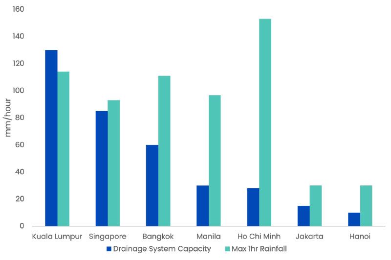
Chart: Drainage System Capacity vs Maximum 1-Hour Rainfall
Kuala Lumpur’s drainage infrastructure is designed to handle rainfall intensities of up to 130 mm per hour, the highest design standard in the region. The city’s recorded one-hour extreme stands at about 114 mm. Severe, but still within its design envelope. The remaining margin roughly 16 mm, may seem small, but it often marks the difference between floods and no floods, or floods that clears within hours and disasters that linger for days.
Recognising this, Malaysia invested more than RM3 billion in flood mitigation across the Klang Valley between 2015 and 2023, aiming to widen that buffer as climate change drives ever more intense rainfall.
The Gap Between Engineering and Expectation
There is a persistent mismatch between public expectations and engineering reality. Most people understandably expect modern infrastructure to prevent flooding entirely. Engineers, however, work toward a different goal: making floods rare, brief, and manageable.
This is where perception diverges from progress. When an intersection floods for 45 minutes instead of eight hours, many see failure. Engineers see a 90% improvement. These “silent savings”, the disasters that did not happen, the damage that was avoided, rarely make headlines, yet they preserve billions of ringgit in economic activity and prevent widespread disruption.
Speed of recovery matters. A neighbourhood that once remained waterlogged for two days but now drains in four hours has fundamentally improved, even if occasional flooding still occurs. The line between disruption and disaster is often measured in hours, not in the simple presence or absence of water.
Why Floods Still Happen
Even well-designed systems have limits. Flooding becomes likely when multiple stress factors align: intense rainfall coinciding with high tides that reduce drainage gradients, debris partially blocking key drainage channels, simultaneous storms across several sub-catchments, or ageing infrastructure in older neighbourhoods.
When extreme rainfall meets high tide and obstructed drains, flooding is almost inevitable. These events are not evidence that “nothing works,” but rather visible signs of systems being pushed beyond their design envelope.
Adapting for What’s Coming
Urban flood management is shifting from a strategy of “drain faster” to one of “hold and slow.” This means more retention basins to store water temporarily, permeable surfaces to encourage gradual absorption, and distributed green infrastructure alongside major engineering works.
The aim is not to eliminate flooding altogether, but to increase flexibility, allowing systems to bend under stress without breaking. Current plans include expanding retention pond networks, upgrading pump capacity in vulnerable areas, and improving real-time monitoring so responses can be anticipatory rather than reactive.
Climate adaptation is not about building a perfect shield. It is about building resilience: systems that recover quickly and continue functioning even when pushed beyond their original design assumptions.